 .pdf
.pdf
1. Context
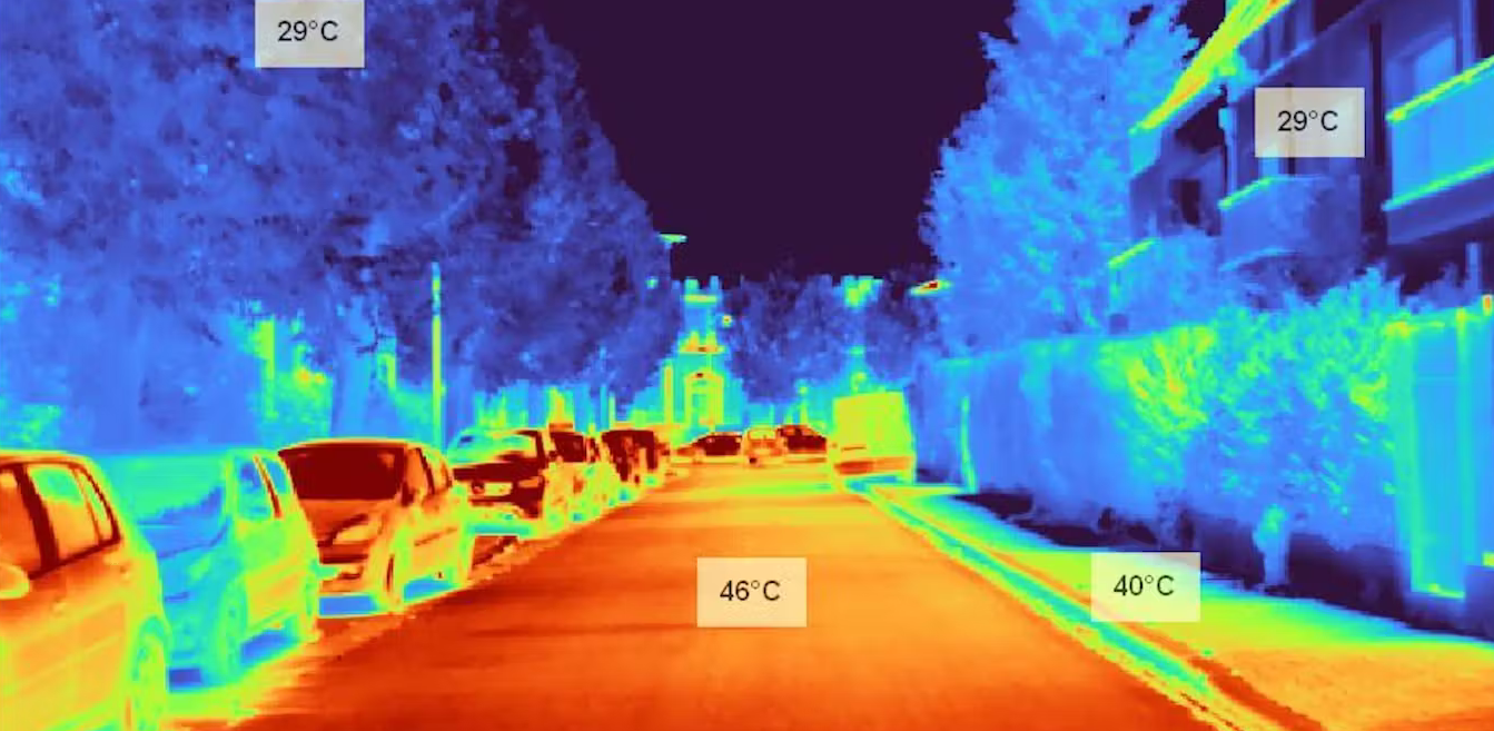
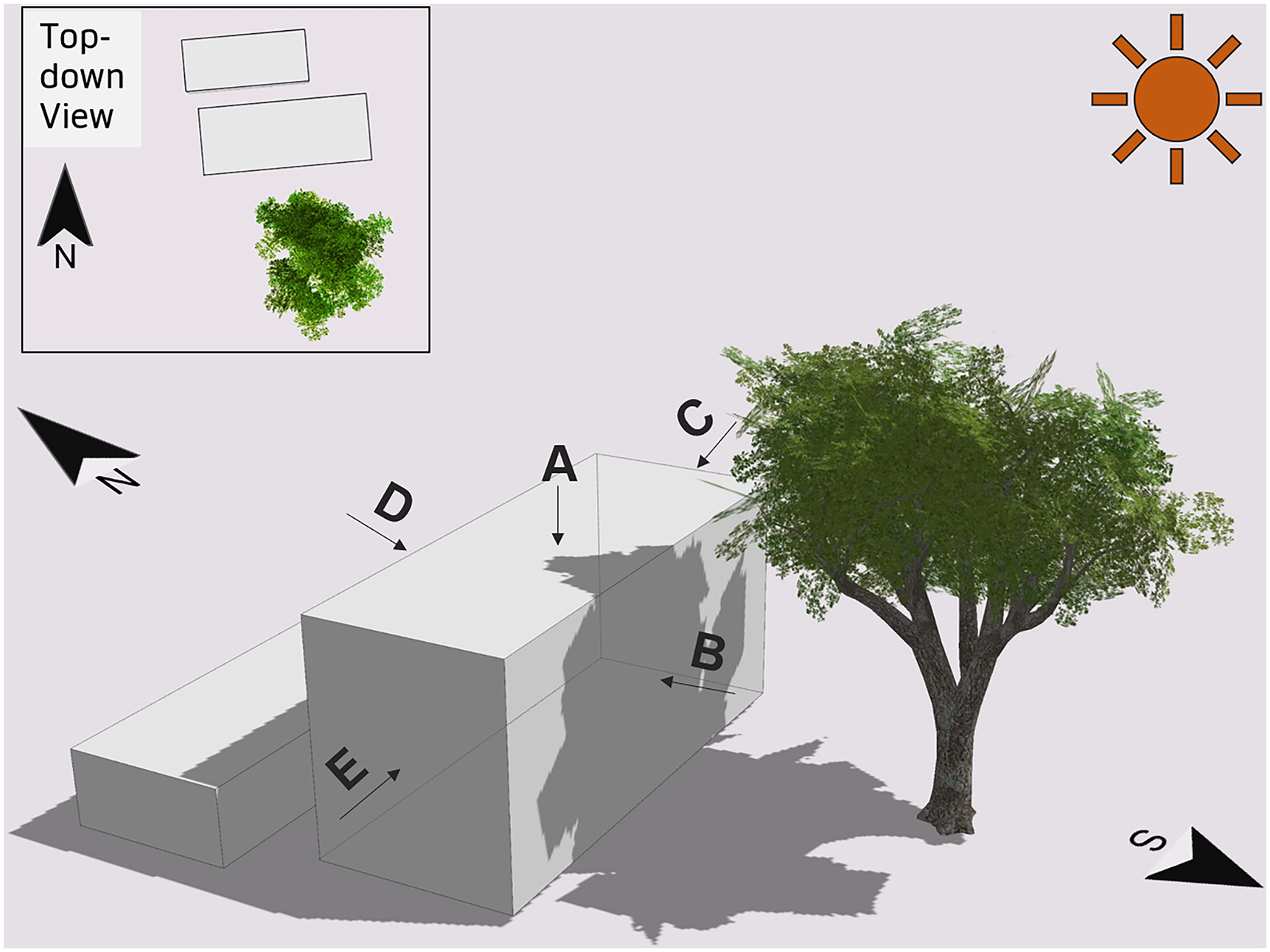
Urban areas are complex ecosystems influenced by various factors, with vegetation, especially trees, playing a crucial role in shaping microclimates, reducing energy consumption, and enhancing overall livability (source).
This Vegetation project aims to integrate trees into 3D geometric models of urban environments to improve the accuracy and realism of thermal and energy simulations.
By leveraging data from OpenStreetMap, a collaborative free geographic database, we will use CGAL, an open-source software library of computational geometry algorithms, and Gmsh , a 3D finite element mesh generator, to generate 3D tree models and integrate them into terrain meshes.
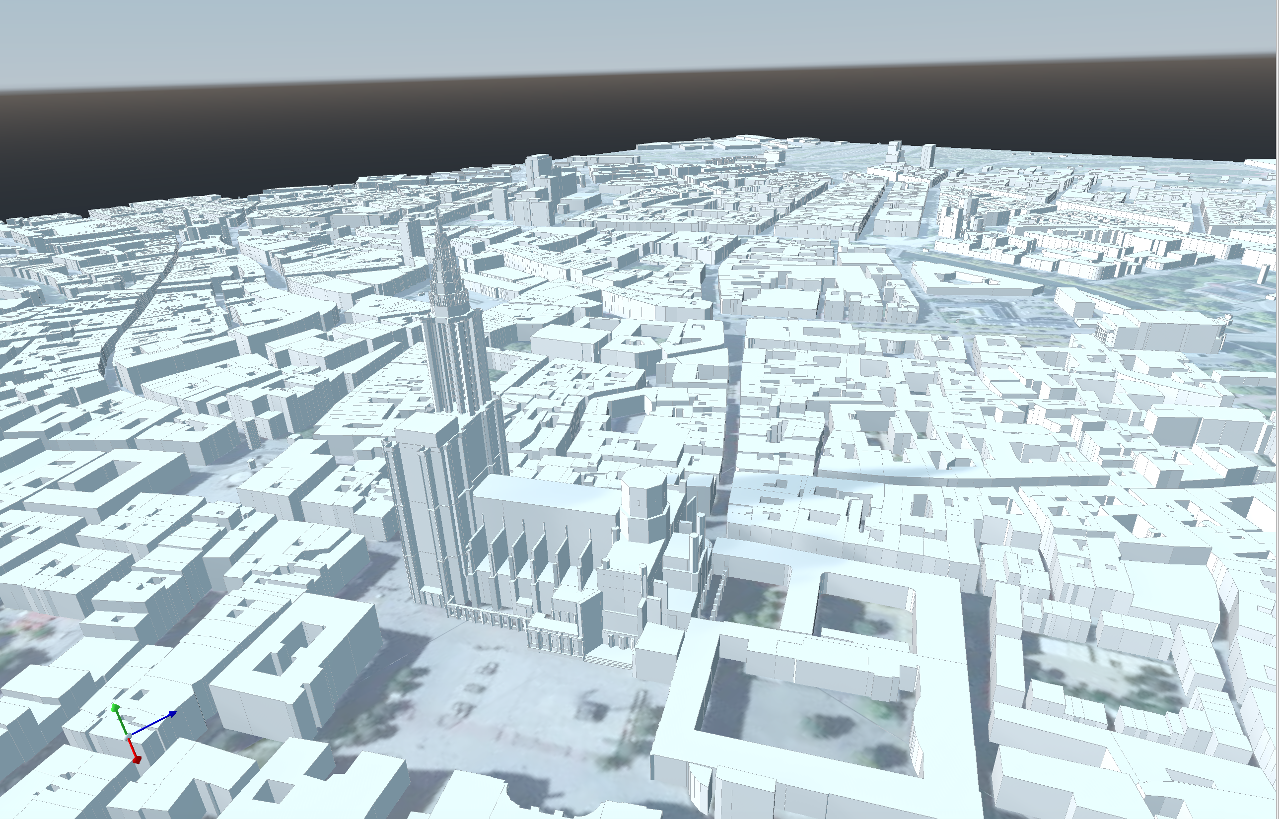
Our primary focus will be on Strasbourg, France. More specifically, we were provided with an .stl file containing a 3D model of the Strasbourg city center:
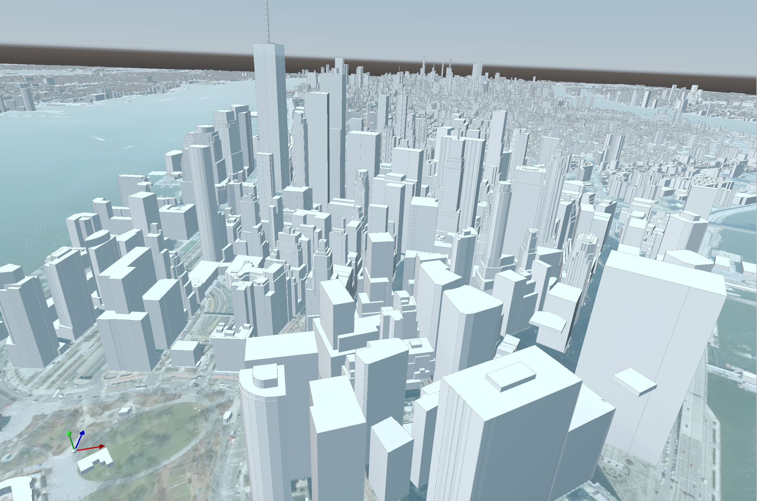
However, the final version of the software will be designed to be easily adaptable to any area. Here’s an example of a 3D model of Manhattan, NYC:
References
-
[verdie15] Yannick Verdie, Florent Lafarge, Pierre Alliez, "LOD Generation for Urban Scenes", ACM Transactions on Graphics, 34(3): 15, 2015, DOI: 10.1145/2766946
-
[verdie14] Yannick Verdie, Florent Lafarge, "Detecting parametric objects in large scenes by Monte Carlo sampling", International Journal of Computer Vision, 106(1): 57—75, 2014, DOI: 10.1007/s11263-013-0641-0
-
[stava14] O. Stava, S. Pirk, J. Kratt, B. Chen, R. Mech, O. Deussen, B. Benes, "Inverse Procedural Modeling of Trees", Preprint, 2014, Adobe Systems Inc., USA; University of Konstanz, Germany; Shenzhen Institute of Advanced Technology, China; Purdue University, USA.
-
[adtree] Shenglan Du, Roderik Lindenbergh, Hugo Ledoux, Jantien Stoter, Liangliang Nan, "AdTree: Accurate, Detailed, and Automatic Modelling of Laser-Scanned Trees", MDPI, 2019, MDPI: 2072-4292/11/8/942
-
[benes] Bedrich Benes, "Computational Vegetation", Computational Vegetation
-
[cgal] CGAL Development Team, "CGAL User and Reference Manual", CGAL User and Reference Manual
-
[feelpp] Feel Consortium, "Feel", Feel++ Documentation
-
[curl] "curl", curl Homepage
-
[meshlab] MeshLab Developers, "MeshLab", MeshLab Homepage
-
[overpass] OpenStreetMap Contributors, "Overpass API", Overpass API
-
[openstreetmap] "OpenStreetMap", OpenStreetMap Help
-
[img:TreeShade] Yujin Park, Jean-Michel Guldmann, Desheng Liu, "Impacts of tree and building shades on the urban heat island: Combining remote sensing, 3D digital city and spatial regression approaches", 2021, ScienceDirect: Impacts of tree and building shades on the urban heat island
-
[img:NY] Christophe Prud’homme, "New York City mesh", 2023, GitHub: New York City mesh
-
[img:aerialview] Conseil départemental de la Somme, "Aerial thermal view", 2023, Aerial thermal view
-
[img:street_thermography] P. Verchere, "Thermal image of a street in the city", 2023, The Conversation: Thermal image of a street in the city
-
[img:mercator] Bibm@th, "Mercator projection", 2024, Bibm@th: Mercator projection
-
[stl] Wikipedia, "STL (file format) - Wikipedia", 2023, Wikipedia: STL (file format)
-
[cgal_alpha_wrapper] Pierre Alliez, David Cohen-Steiner, Michael Hemmer, Cédric Portaneri, Mael Rouxel-Labbé, "CGAL 5.6.1 - 3D Alpha Wrapping", 2024, CGAL: 3D Alpha Wrapping
-
[cgal_affine_transformation] CGAL Development Team, "CGAL 5.6.1 - 2D and 3D Linear Geometry Kernel", 2024, CGAL: 2D and 3D Linear Geometry Kernel
-
[wgs84] Wikipedia, "World Geodetic System", 2024, Wikipedia: World Geodetic System
-
[wgs84_to_cartesian] Christian Berger, "WGS84toCartesian", 2021, GitHub: WGS84toCartesian
-
[k-nn] Wikipedia, "K-nearest neighbors algorithm", 2024, Wikipedia: K-nearest neighbors algorithm
-
[mercator-proj] Wikipedia, "Mercator projection", 2024, Wikipedia: Mercator projection
-
[sketchup] Wikipedia, "SketchUp", 2024, Wikipedia: SketchUp
-
[json] Wikipedia, "JSON", 2024, Wikipedia: JSON
-
[corefine-compute] CGAL Development Team, "CGAL 5.6.1 - 3D Alpha Shapes", 2024, CGAL: 3D Alpha Shapes
-
[hidalgo2-ubm] HiDALGO2, "Hidalgo2-UBM", 2024, HiDALGO2: Urban Building Model
-
[hidalgo2] HiDALGO2, "HiDALGO2", 2024, HiDALGO2 Homepage
-
[green-deal] European Commission, "European Green Deal", 2024, European Green Deal
-
[delaunay-wiki] Wikipedia, "Delaunay triangulation", 2024, Wikipedia: Delaunay triangulation
-
[hidalgo2-about] HiDALGO2, "About HiDALGO2", 2024, HiDALGO2: About
-
[cemosis] Cemosis, "Cemosis", 2024, Cemosis Homepage
-
[irma] IRMA, "IRMA", 2024, IRMA Homepage
-
[inria] INRIA, "INRIA", 2024, INRIA Homepage
-
[alliez] Pierre Alliez, "Pierre Alliez", 2024, Pierre Alliez Homepage
-
[chabannes] Vincent Chabannes, "Vincent Chabannes", 2024, ResearchGate: Vincent Chabannes
-
[paraview] Kitware, "ParaView", 2024, ParaView Homepage
-
[cgal-master] CGAL Development Team, "CGAL", 2024, CGAL GitHub
-
[overpass-ql] Roland Olbricht, "Overpass QL", 2024, Overpass QL
-
[overpass-turbo] Roland Olbricht, Martin Raifer, "Overpass turbo", 2024, Overpass turbo
-
[exaMA] ExaMA Consortium, "Exa-MA", 2024, Exa-MA: Methods and Algorithms for Exascale
-
[numpex] Numpex Consortium, "Numpex", 2024, Numpex Homepage
-
[gmsh] Christophe Geuzaine, Jean-François Remacle, "Gmsh", 2024, Gmsh Homepage
-
[img:tree-shape] Noriah Othman, Mashitah Mat Isa, Noralizawati Mohamed, Ramly Hasan, "Street Planting Compositions: The Public and Expert Perspectives", 2019, ResearchGate: Street Planting Compositions
-
[prudhomme] Christophe Prud’homme, "Christophe Prud’homme", 2024, ResearchGate: Christophe Prud’homme
-
[auto-refine-triangle-soup] CGAL Development Team, "CGAL 6.0 - Polygon Mesh Processing", 2024, CGAL: Polygon Mesh Processing
-
[cpr] CPR Developers, "Cpp Requests: Curl for People", 2024, GitHub: Cpp Requests
-
[pouvoir-arbre] Tania Landes , "The Conversation: D’où vient le pouvoir rafraîchissant des arbres en ville ?", 2023, The Conversation: D’où vient le pouvoir rafraîchissant des arbres en ville?
-
[science-direct] Yujin Park, Jean-Michel Guldmann, Desheng Liu, "Impacts of tree and building shades on the urban heat island: Combining remote sensing, 3D digital city and spatial regression approaches", 2021, ScienceDirect: Impacts of tree and building shades on the urban heat island
-
[gmsh-geo] Gmsh Developers, "Gmsh .geo file format", 2024, Gmsh .geo file format
-
[highest-plants] New Scientist - Aisling Irwin, "World’s highest plants discovered growing 6km above sea level", 2016, New Scientist: World’s highest plants discovered growing 6km above sea level
-
[raycasting] Wikipedia, "Ray casting", 2024, Wikipedia: Ray casting
-
[bvh] Wikipedia, "Bounding volume hierarchy", 2024, Wikipedia: Bounding volume hierarchy
-
[kd-tree] Wikipedia, "K-d tree", 2024, Wikipedia: K-d tree
-
[async] cplusplus.com, "std::async", 2024, cplusplus.com: std::async
-
[is_valid] CGAL Development Team, "CGAL 5.6.1 - 3D Mesh Generation", 2024, link:https://doc.cgal.org/latest/Surface_mesh/classCGAL_1_1Surface__mesh.html#a14cb5e4c51a02d652ba33bf906f39fc0[CGAL: is_valid()
-
[auto_refine_triangle_soup]] CGAL Development Team, "CGAL 6.0 - Polygon Mesh Processing", 2024, CGAL: autorefine_triangle_soup()
-
[deep_learning] Wikipedia, "Deep learning", 2024, Wikipedia: Deep learning
-
[numpex_exama] Numpex, "Exa-MA PC1", 2024, Numpex: Exa-MA PC1