 .pdf
.pdf
Tree Placement
Generated tree models will be integrated into terrain meshes to create comprehensive 3D urban models. To ensure precise integration into the terrain mesh (especially for large areas), the tree models' GPS coordinates (latitude, longitude) will be converted to Cartesian coordinates (x, y) using a Mercator projection.
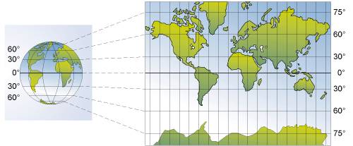
This is the most common way to represent the Earth’s surface on a plane and has the advantage of being conformal, meaning that it preserves angles locally (hence its usage in sailings).
In a Mercator projection, parallels and meridians are represented by straight orthogonal lines, with the equator being the horizontal line placed at the center of the map. The other parallels must necessarily be stretched (east-west stretching). This stretching is accompanied by a corresponding north-south stretching, so that the north-south scale is equal to the east-west scale everywhere.
Mathematically, the Mercator projection is defined as follows: if a point on the sphere has a latitude φ and longitude λ (with λ0 placed at the center of the map), then its projection on the Mercator map will have coordinates:
To achieve this while taking into account that the Earth is not a perfect sphere, we will assume the Earth is a geodesic defined as WGS84 and use the WGS84toCartesian open-source header-only library to convert the coordinates.
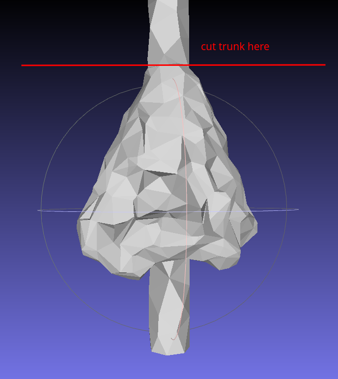
The scaled foliage will be placed with the top of the bounding box at the height of the tree. The trunk will be on the ground at the position of the tree while taking the terrain elevation into account. To make sure the trunk is always at the right height, we will use an abnormally long trunk that will be cut to the right height. This will allow us to avoid having either the trunk floating in the air below the foliage or poking through it.
We will then need to place the whole tree at the correct altitude. To do this, we will need to retrieve the terrain elevation at the tree’s position. There are multiple approches possible to achieve this, the most naive one would be to iterate over all the vertices of the terrain mesh and find the closest one to the tree. This is of course very inefficient. A better approach could be to use a raycasting algorithm to find the intersection between the terrain mesh and a ray. The range we could use for this ray could be from -400m (Deep Sea, located at the border of Israel and Jordan) to 6000m (the highest plants discovered growing 6km above sea level). To be more efficient, we could use the min and max altitude of the terrain mesh we are working on.
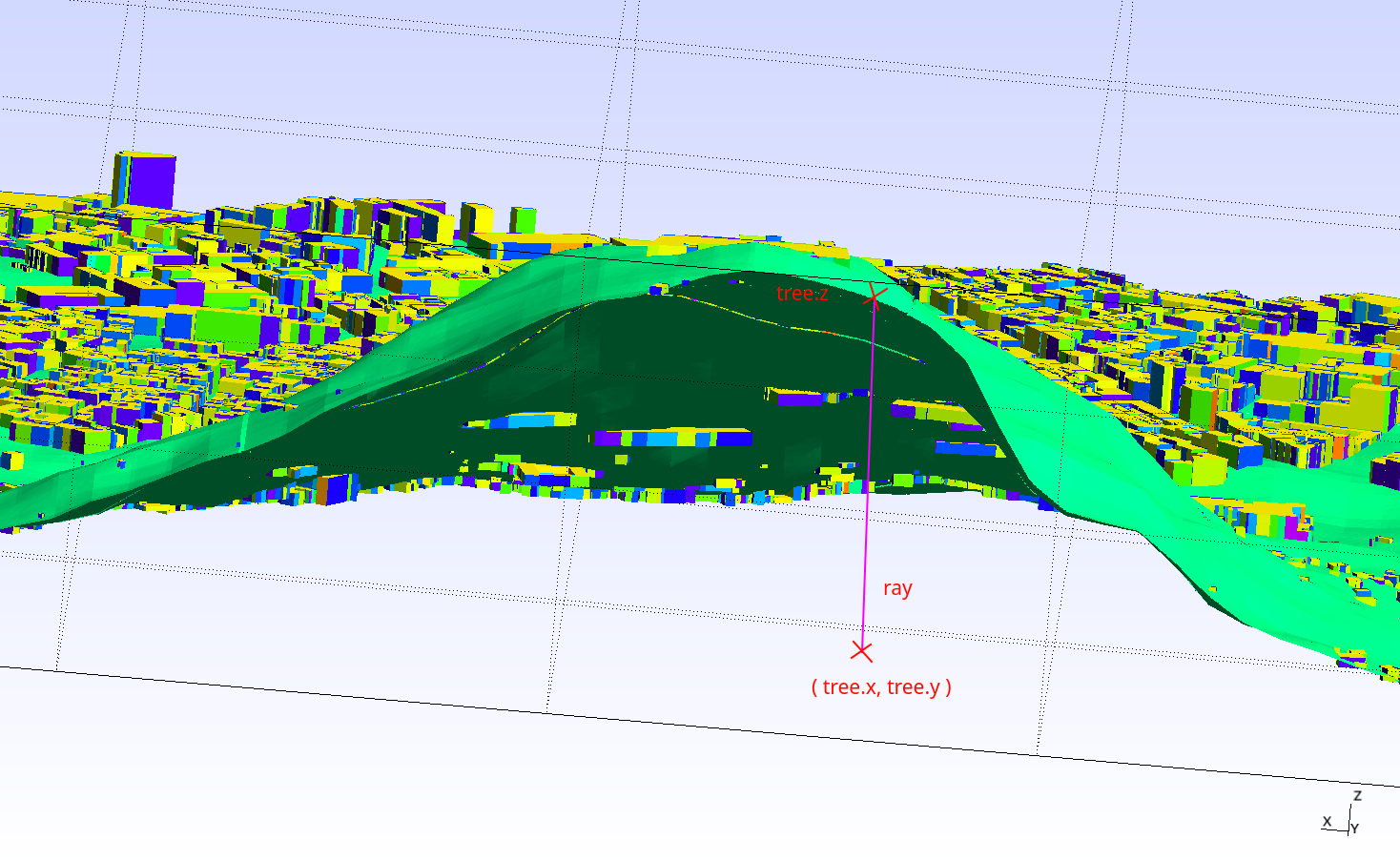
It is important to note that in order to avoid to compute the possible intersection will all the triangles of the terrain mesh, raycasting techniques often use a spatial data structure to accelerate the search. For example, a bounding volume hierarchy (bvh) or a K-d tree could be used.
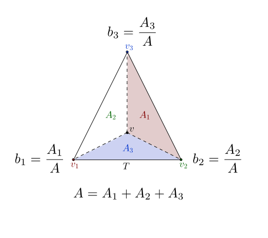
To precisely compute the z coordinate of the tree we can use a barycentric interpolation on the triangle of the terrain mesh that contains the tree. This will allow us to compute the z coordinate of the tree with a high precision especially if the triangle we land on is not flat and/or is very large.
References
-
[verdie15] Yannick Verdie, Florent Lafarge, Pierre Alliez, "LOD Generation for Urban Scenes", ACM Transactions on Graphics, 34(3): 15, 2015, DOI: 10.1145/2766946
-
[verdie14] Yannick Verdie, Florent Lafarge, "Detecting parametric objects in large scenes by Monte Carlo sampling", International Journal of Computer Vision, 106(1): 57—75, 2014, DOI: 10.1007/s11263-013-0641-0
-
[stava14] O. Stava, S. Pirk, J. Kratt, B. Chen, R. Mech, O. Deussen, B. Benes, "Inverse Procedural Modeling of Trees", Preprint, 2014, Adobe Systems Inc., USA; University of Konstanz, Germany; Shenzhen Institute of Advanced Technology, China; Purdue University, USA.
-
[adtree] Shenglan Du, Roderik Lindenbergh, Hugo Ledoux, Jantien Stoter, Liangliang Nan, "AdTree: Accurate, Detailed, and Automatic Modelling of Laser-Scanned Trees", MDPI, 2019, MDPI: 2072-4292/11/8/942
-
[benes] Bedrich Benes, "Computational Vegetation", Computational Vegetation
-
[cgal] CGAL Development Team, "CGAL User and Reference Manual", CGAL User and Reference Manual
-
[feelpp] Feel Consortium, "Feel", Feel++ Documentation
-
[curl] "curl", curl Homepage
-
[meshlab] MeshLab Developers, "MeshLab", MeshLab Homepage
-
[overpass] OpenStreetMap Contributors, "Overpass API", Overpass API
-
[openstreetmap] "OpenStreetMap", OpenStreetMap Help
-
[img:TreeShade] Yujin Park, Jean-Michel Guldmann, Desheng Liu, "Impacts of tree and building shades on the urban heat island: Combining remote sensing, 3D digital city and spatial regression approaches", 2021, ScienceDirect: Impacts of tree and building shades on the urban heat island
-
[img:NY] Christophe Prud’homme, "New York City mesh", 2023, GitHub: New York City mesh
-
[img:aerialview] Conseil départemental de la Somme, "Aerial thermal view", 2023, Aerial thermal view
-
[img:street_thermography] P. Verchere, "Thermal image of a street in the city", 2023, The Conversation: Thermal image of a street in the city
-
[img:mercator] Bibm@th, "Mercator projection", 2024, Bibm@th: Mercator projection
-
[stl] Wikipedia, "STL (file format) - Wikipedia", 2023, Wikipedia: STL (file format)
-
[cgal_alpha_wrapper] Pierre Alliez, David Cohen-Steiner, Michael Hemmer, Cédric Portaneri, Mael Rouxel-Labbé, "CGAL 5.6.1 - 3D Alpha Wrapping", 2024, CGAL: 3D Alpha Wrapping
-
[cgal_affine_transformation] CGAL Development Team, "CGAL 5.6.1 - 2D and 3D Linear Geometry Kernel", 2024, CGAL: 2D and 3D Linear Geometry Kernel
-
[wgs84] Wikipedia, "World Geodetic System", 2024, Wikipedia: World Geodetic System
-
[wgs84_to_cartesian] Christian Berger, "WGS84toCartesian", 2021, GitHub: WGS84toCartesian
-
[k-nn] Wikipedia, "K-nearest neighbors algorithm", 2024, Wikipedia: K-nearest neighbors algorithm
-
[mercator-proj] Wikipedia, "Mercator projection", 2024, Wikipedia: Mercator projection
-
[sketchup] Wikipedia, "SketchUp", 2024, Wikipedia: SketchUp
-
[json] Wikipedia, "JSON", 2024, Wikipedia: JSON
-
[corefine-compute] CGAL Development Team, "CGAL 5.6.1 - 3D Alpha Shapes", 2024, CGAL: 3D Alpha Shapes
-
[hidalgo2-ubm] HiDALGO2, "Hidalgo2-UBM", 2024, HiDALGO2: Urban Building Model
-
[hidalgo2] HiDALGO2, "HiDALGO2", 2024, HiDALGO2 Homepage
-
[green-deal] European Commission, "European Green Deal", 2024, European Green Deal
-
[delaunay-wiki] Wikipedia, "Delaunay triangulation", 2024, Wikipedia: Delaunay triangulation
-
[hidalgo2-about] HiDALGO2, "About HiDALGO2", 2024, HiDALGO2: About
-
[cemosis] Cemosis, "Cemosis", 2024, Cemosis Homepage
-
[irma] IRMA, "IRMA", 2024, IRMA Homepage
-
[inria] INRIA, "INRIA", 2024, INRIA Homepage
-
[alliez] Pierre Alliez, "Pierre Alliez", 2024, Pierre Alliez Homepage
-
[chabannes] Vincent Chabannes, "Vincent Chabannes", 2024, ResearchGate: Vincent Chabannes
-
[paraview] Kitware, "ParaView", 2024, ParaView Homepage
-
[cgal-master] CGAL Development Team, "CGAL", 2024, CGAL GitHub
-
[overpass-ql] Roland Olbricht, "Overpass QL", 2024, Overpass QL
-
[overpass-turbo] Roland Olbricht, Martin Raifer, "Overpass turbo", 2024, Overpass turbo
-
[exaMA] ExaMA Consortium, "Exa-MA", 2024, Exa-MA: Methods and Algorithms for Exascale
-
[numpex] Numpex Consortium, "Numpex", 2024, Numpex Homepage
-
[gmsh] Christophe Geuzaine, Jean-François Remacle, "Gmsh", 2024, Gmsh Homepage
-
[img:tree-shape] Noriah Othman, Mashitah Mat Isa, Noralizawati Mohamed, Ramly Hasan, "Street Planting Compositions: The Public and Expert Perspectives", 2019, ResearchGate: Street Planting Compositions
-
[prudhomme] Christophe Prud’homme, "Christophe Prud’homme", 2024, ResearchGate: Christophe Prud’homme
-
[auto-refine-triangle-soup] CGAL Development Team, "CGAL 6.0 - Polygon Mesh Processing", 2024, CGAL: Polygon Mesh Processing
-
[cpr] CPR Developers, "Cpp Requests: Curl for People", 2024, GitHub: Cpp Requests
-
[pouvoir-arbre] Tania Landes , "The Conversation: D’où vient le pouvoir rafraîchissant des arbres en ville ?", 2023, The Conversation: D’où vient le pouvoir rafraîchissant des arbres en ville?
-
[science-direct] Yujin Park, Jean-Michel Guldmann, Desheng Liu, "Impacts of tree and building shades on the urban heat island: Combining remote sensing, 3D digital city and spatial regression approaches", 2021, ScienceDirect: Impacts of tree and building shades on the urban heat island
-
[gmsh-geo] Gmsh Developers, "Gmsh .geo file format", 2024, Gmsh .geo file format
-
[highest-plants] New Scientist - Aisling Irwin, "World’s highest plants discovered growing 6km above sea level", 2016, New Scientist: World’s highest plants discovered growing 6km above sea level
-
[raycasting] Wikipedia, "Ray casting", 2024, Wikipedia: Ray casting
-
[bvh] Wikipedia, "Bounding volume hierarchy", 2024, Wikipedia: Bounding volume hierarchy
-
[kd-tree] Wikipedia, "K-d tree", 2024, Wikipedia: K-d tree
-
[async] cplusplus.com, "std::async", 2024, cplusplus.com: std::async
-
[is_valid] CGAL Development Team, "CGAL 5.6.1 - 3D Mesh Generation", 2024, link:https://doc.cgal.org/latest/Surface_mesh/classCGAL_1_1Surface__mesh.html#a14cb5e4c51a02d652ba33bf906f39fc0[CGAL: is_valid()
-
[auto_refine_triangle_soup]] CGAL Development Team, "CGAL 6.0 - Polygon Mesh Processing", 2024, CGAL: autorefine_triangle_soup()
-
[deep_learning] Wikipedia, "Deep learning", 2024, Wikipedia: Deep learning
-
[numpex_exama] Numpex, "Exa-MA PC1", 2024, Numpex: Exa-MA PC1